The integration of drone technology has become increasingly prevalent across various enterprise and commercial sectors, offering significant advancements in efficiency, accuracy, and safety. Among the diverse applications of drones, Lidar (Light Detection and Ranging) technology stands out for its capability to acquire precise three-dimensional data, making it an indispensable tool for industries requiring detailed geospatial information. The DJI Zenmuse L2 emerges as a state-of-the-art Lidar solution specifically engineered to meet the demanding needs of professional applications, combining a frame Lidar, a self-developed high-accuracy Inertial Measurement Unit (IMU) system, and a 4/3 CMOS RGB mapping camera. This integration signifies a comprehensive approach to data acquisition, promising a high degree of accuracy and versatility for enterprise operations.
The Zenmuse L2 offers several key benefits that are particularly advantageous for enterprise clients. These include enhanced accuracy in data capture, exceptional efficiency in large-area surveying, and superior penetration through vegetation, expanding the scope of possible applications. This buyer's guide aims to provide an in-depth exploration of the DJI Zenmuse L2's features, use cases, and critical considerations for enterprise and commercial clients, ultimately assisting in making well-informed purchasing decisions.
Is the Zenmuse L2 Right for Your Business? Identifying Key Applications
This guide is tailored for enterprise and commercial clients seeking to leverage advanced aerial Lidar technology for their operations. The DJI Zenmuse L2 is ideally suited for industries requiring high-precision 3D data, including:
- Surveying and Mapping: For topographic surveys, cadastral mapping, and creating high-resolution DEMs and DSMs.
- Construction: For site management, progress tracking, as-built surveys, and integration with BIM workflows.
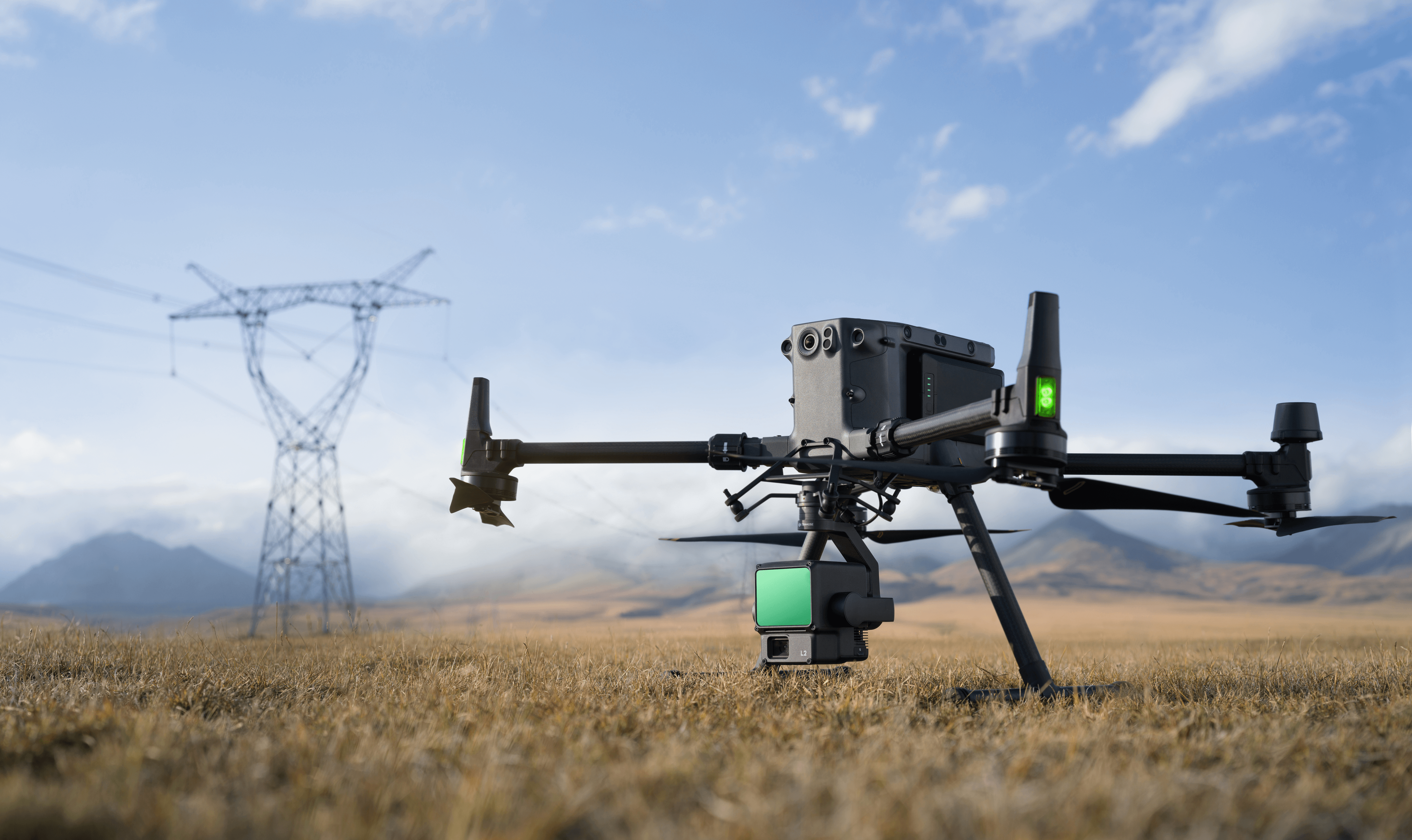
- Infrastructure Inspection: For detailed inspections of power lines, bridges, railways, and other critical assets.
- Forestry: For forest inventory, tree counting, biomass estimation, and generating accurate terrain models under dense canopies.
- Mining: For mine surveying, volume calculations, and monitoring slope stability.
- Agriculture: For precision agriculture practices and comprehensive crop monitoring.
- Environmental Monitoring: For tracking erosion, mapping habitats, and disaster response.
Consider if your organization's needs align with these applications. The following sections will provide a deeper understanding of the features and specifications that make the DJI Zenmuse L2 a powerful tool for these sectors.
Key Features and Technical Specifications: Precision Data Acquisition
The DJI Zenmuse L2 is a sophisticated system integrating three key components for high-precision geospatial data acquisition: a Lidar sensor, an RGB camera, and a high-accuracy IMU.
-
Lidar Sensor:
- Accuracy: 2 cm ranging accuracy at 150 m. Horizontal: 5 cm @ 150 m; Vertical: 4 cm @ 150 m system accuracy.
- Point Cloud Rate: Up to 240,000 points per second (single return), 1,200,000 points per second (multiple returns).
- Detection Range: 450 m @ 50% reflectivity, 0 klx; 250 m @ 10% reflectivity, 100 klx.
- Scanning Modes: Repetitive and non-repetitive.
- Max Returns: Supports up to 5 returns for enhanced vegetation penetration.
- Laser Spot Size: 4x12 cm @ 100 m, enabling detection of finer details.
-
RGB Mapping Camera:
- Sensor: 4/3 CMOS, 20 MP effective pixels.
- Lens: 84° FOV, 24 mm equivalent focal length, f/2.8-f/11 aperture.
- Shutter: Mechanical (2-1/2000 s) and electronic (2-1/8000 s), 200,000 shutter count.
- Video Resolution: Up to 4K @ 30fps.
-
Photo Interval: Minimum 0.7 seconds.
-
High-Accuracy IMU System:
- Update Frequency: 200 Hz.
- Positioning Accuracy (RTK FIX): Horizontal: 1 cm + 1 ppm; Vertical: 1.5 cm + 1 ppm.
-
Warm-up Time: None required, allowing for immediate operation.
-
Other Features:
- IP Rating: IP54 for dust and water resistance.
- Point Cloud LiveView: Real-time visualization of point cloud data.
- One-Click Processing: Streamlined data processing with DJI Terra.
- Power Line Follow Mode: Intelligent mode for automated power line inspection.
- Simultaneous Lidar and Photogrammetry: Integrated data capture in a single flight.
- Compatibility: DJI Matrice 300 RTK (with DJI RC Plus) and Matrice 350 RTK.
To summarize the key technical specifications:
| Specification | Detail |
|---|---|
| Lidar Sensor | |
| Ranging Accuracy | 2 cm @ 150 m |
| System Accuracy (Horiz/Vert) | 5 cm / 4 cm @ 150 m |
| Point Cloud Rate (Single/Multi) | 240,000 / 1,200,000 pts/s |
| Detection Range (50%/10% Refl.) | 450 m / 250 m |
| Max Returns | 5 |
| Laser Spot Size | 4x12 cm @ 100 m |
| RGB Mapping Camera | |
| Sensor | 4/3 CMOS, 20 MP |
| FOV/Focal Length/Aperture | 84° / 24 mm equiv. / f/2.8-f/11 |
| Shutter (Mech/Elec) | 2-1/2000 s / 2-1/8000 s, 200K count |
| Video Resolution | Up to 4K @ 30fps |
| Min Photo Interval | 0.7 s |
| IMU System | |
| Update Frequency | 200 Hz |
| Positioning Accuracy (RTK FIX) | Horizontal: 1 cm + 1 ppm; Vertical: 1.5 cm + 1 ppm |
| Warm-up Time | None |
| General | |
| IP Rating | IP54 |
| Supported Aircraft | Matrice 300 RTK (w/ RC Plus), Matrice 350 RTK |
| Software Compatibility | DJI Terra |
| Special Features | Point Cloud LiveView, One-Click Processing, Power Line Follow, Simultaneous Lidar & Photogrammetry |
Unlocking Its Potential: Enterprise and Commercial Use Cases
The advanced features of the DJI Zenmuse L2 enable a wide array of applications across various industries:
- Surveying and Mapping: Achieve high accuracy and efficiency in topographic surveys, cadastral mapping, and creating detailed 3D models for urban planning, construction, and environmental research. The L2's centimeter-level accuracy is crucial for reliable boundary mapping and legal surveys. It excels in generating precise DEMs and DSMs for terrain analysis and flood risk assessment.
- Construction: Revolutionize site management and progress tracking by capturing real-time 3D data for accurate as-built surveys and BIM integration. The L2 facilitates precise volume calculations for earthwork movements and enables faster data acquisition even at higher altitudes.
- Infrastructure Inspection: Ensure the safety and longevity of critical assets like power lines, bridges, and railways through detailed inspections. The Power Line Follow mode automates power line inspections, increasing safety and efficiency. The high-resolution 3D models aid in structural analysis and maintenance planning.
- Forestry: Enable sustainable forest management with accurate tree counting, individual tree segmentation, and biomass estimation. The L2's superior vegetation penetration and ability to generate detailed DEMs and DSMs are invaluable for forest inventory and health monitoring.
- Mining: Optimize mining operations with rapid and accurate mine surveying and volume calculations. The detailed 3D models generated by the L2 also help monitor slope stability and identify potential hazards, enhancing worker safety.
- Agriculture: Enhance precision agriculture with detailed crop health monitoring and analysis. The L2's high accuracy provides valuable insights for optimizing yields and resource management.
- Environmental Monitoring: Support conservation efforts with effective wildlife tracking and habitat mapping. The L2's detailed data aids in assessing environmental changes and managing natural resources.
What Matters to Enterprise Clients: Key Purchasing Considerations
When investing in a Lidar system like the DJI Zenmuse L2, enterprise clients should consider several key factors:
- Accuracy Requirements: Evaluate the specific accuracy needed for your applications. The L2's 4 cm vertical and 5 cm horizontal accuracy at 150 m altitude make it suitable for demanding tasks.
- Drone Platform Integration: Ensure compatibility with your existing drone fleet. The L2 seamlessly integrates with DJI Matrice 300 RTK (with DJI RC Plus) and Matrice 350 RTK platforms.
- Software and Data Processing: Consider the software ecosystem. The L2 is fully compatible with DJI Terra for efficient post-processing, including point cloud generation, ground point classification, and DEM creation.
- Data Output Formats: Verify that the system supports your required data formats. The L2 exports point clouds in PNTS, LAS, PLY, PCD, and S3MB formats, ensuring interoperability with various GIS and CAD software.
- Cost and ROI: Analyze the total cost of ownership and the potential return on investment. The L2's efficiency and accuracy can lead to significant cost savings through reduced field time and improved data quality.
- Payload Capacity: While the L2 is a comprehensive payload, consider the overall payload capacity of your drone platform if you need to carry additional sensors or equipment.
- Training and Support: Assess the availability of training resources and technical support from the manufacturer to ensure effective utilization of the system.
Expert Opinions and User Insights: What the Industry Says
Industry reviews and user experiences highlight the DJI Zenmuse L2 as a significant advancement in aerial Lidar technology. Users praise its improved accuracy, extended detection range, higher point cloud density, and enhanced vegetation penetration compared to its predecessor, the L1. The absence of IMU warm-up time is also noted as a significant improvement in operational efficiency. While the initial investment is a consideration, the L2 is often seen as a cost-effective solution compared to higher-end Lidar systems, offering a compelling balance of performance and price for enterprise applications.
The DJI Zenmuse L2 Lidar camera offers a powerful and efficient solution for enterprise and commercial clients requiring high-precision geospatial data. Its advanced Lidar sensor, integrated RGB camera, and high-accuracy IMU system provide unparalleled accuracy and detail for a wide range of applications. With its seamless integration into the DJI ecosystem and intelligent features, the Zenmuse L2 is a valuable investment for organizations looking to enhance their surveying, mapping, inspection, and environmental monitoring capabilities.
Ready to experience the precision and efficiency of the DJI Zenmuse L2? Contact us today for a personalized consultation and quote. Visit our product page for detailed specifications and to explore our range of enterprise drone solutions. Request a demonstration to see the L2 in action and learn how it can transform your operations.
Share:
DJI Zenmuse H30T: The Ultimate Buyer's Guide for Enterprise Applications
Autel EVO Max Series: Complete Buyer's Guide 2026 (4T XE, 4N & Accessories)