

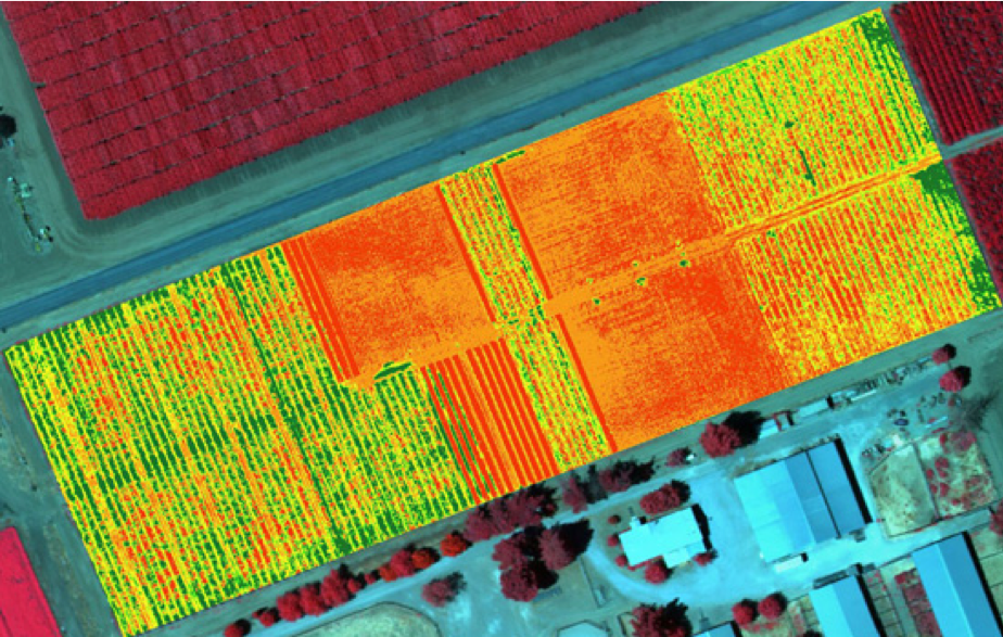
Multispectral drones are revolutionizing how we see and manage our environment, especially in agriculture. These specialized Unmanned Aerial Vehicles (UAVs) capture light beyond what our eyes can see, providing invaluable insights into plant health, environmental conditions, and more. This article will explore what multispectral drones are, how they work, and whether they're the right investment for your needs.

Multispectral Drones: What Are They and Who Needs Them?
Introduction – A New Eye in the Sky for Agriculture
Imagine being able to spot plant diseases or nutrient deficiencies weeks before they become visible to the naked eye. That’s the power of multispectral . They’re equipped with advanced cameras that can “see” the invisible, gathering rich data on everything from crop stress to water issues. This technology is rapidly becoming indispensable for modern farming, land management, and environmental monitoring, allowing professionals to make smarter, more sustainable decisions.
Beyond crop monitoring, multispectral drones are also being used for livestock management and urban green area surveys, demonstrating their versatility in supporting animal health, resource management, and environmental assessment in diverse settings.

How Multispectral Drone Technology Works
Multispectral Cameras 101 – Capturing Light Beyond RGB
A multispectral drone isn’t just a regular drone with a fancy camera. It’s a complete system featuring specialized cameras that capture images across multiple specific wavelengths of light, far beyond the standard red, green, and blue (RGB) visible spectrum. This means that in addition to capturing regular color photos, these drones record reflectance in non-visible bands like near-infrared (NIR) and red-edge, which contain crucial information about plant and soil properties.
As the drone flies a survey grid, the camera snaps synchronized images in each band. These cameras often use multiple sensors or lenses, each with a filter for a specific wavelength, to capture these different light signatures simultaneously. Many also include a sunlight sensor on top of the drone to measure ambient light, ensuring the data is accurately calibrated for precise reflectance readings. Later, specialized software combines these images into “stacked” maps where each pixel has multi-band values, enabling detailed analysis.
For instance, a healthy green plant reflects a lot of near-infrared light while absorbing most of the red light. When a plant is stressed, this reflectance signature changes, and multispectral cameras are designed to detect these subtle shifts. Current multispectral drones typically capture 4–6 discrete bands of light. For example, DJI’s Mavic 3 Multispectral (M3M) includes four bands (Green, Red, Red Edge, Near-IR) plus an RGB camera, while high-end sensors like the MicaSense RedEdge-P capture five narrow bands (Blue, Green, Red, Red Edge, NIR) along with a high resolution panchromatic band. This high resolution panchromatic band enables the creation of sharper, pan-sharpened images for detailed mapping and analysis. This multi-band capability is what truly sets them apart.

From Raw Bands to Insight – NDVI and Other Indices Explained
To make sense of all this spectral data, vegetation indices are used. These are formulas that transform the raw data into easy-to-understand indicators of plant health and vigor. The most common index is the Normalized Difference Vegetation Index (NDVI).
NDVI uses the difference between Near-Infrared (NIR) and Red light reflectance to quantify greenness and plant vigor. Healthy plants, with their high chlorophyll content, strongly reflect NIR light and absorb red light, resulting in high NDVI values (typically ranging from 0.7 to 0.9). Stressed or sparse vegetation, however, reflects less NIR and/or more red light, leading to lower NDVI values (e.g., 0.3 to 0.5 for stressed areas, near 0 for bare soil).
Another important index is the Normalized Difference Red Edge (NDRE). Similar to NDVI, NDRE uses the Red Edge band instead of the Red band. The Red Edge band (around 710 nm) is particularly sensitive to early changes in chlorophyll content, making NDRE excellent for detecting subtle stress in later growth stages or in dense canopies where NDVI might "saturate" or become less sensitive.
These indices are critical because they simplify complex spectral data into intuitive, color-coded maps (e.g., red for poor health, green for healthy). This allows farmers and agronomists to quickly identify problem areas in a field, guiding them on where to scout on the ground or apply targeted treatments.

Multispectral vs. Thermal vs. Hyperspectral (Sensor Differences)
It’s easy to get confused by the various “spectral” drone sensors. Here’s how multispectral, thermal, and hyperspectral cameras differ:
-
Multispectral: As discussed, these cameras capture a handful of distinct, relatively broad spectral bands (typically 4-6). They are widely used for vegetation analysis and land classification due to their balance of data richness and manageable complexity.
-
Thermal: Also known as long-wave infrared cameras, thermal sensors detect heat radiation emitted by objects, measuring surface temperature. They are primarily used for spotting irrigation issues, detecting heat stress in plants, identifying animal presence, or inspecting infrastructure like solar panels. Thermal images generally have lower resolution than multispectral ones. When combined with multispectral data, thermal enables comprehensive crop monitoring, pest detection, and nighttime field inspections by revealing temperature anomalies and issues not visible in multispectral data.
-
Hyperspectral: These are the most advanced sensors, capturing hundreds of very narrow, contiguous spectral bands. This provides an incredibly detailed “spectral signature” for each pixel, allowing for highly precise identification of materials, plant species, or even mineral compositions. However, hyperspectral drones are rare, expensive (often $100K+ for the sensor alone), and generate massive datasets requiring specialized analysis, usually reserved for advanced research or niche applications.
In essence, multispectral offers a practical balance for routine monitoring, thermal focuses on temperature, and hyperspectral provides unparalleled, but complex, spectral detail. In agriculture, many professionals often combine multispectral (for plant health) and thermal (for water stress) data for a more comprehensive understanding.

Data Collection and Analysis
Flight Planning and Data Capture – Getting Reliable Results
Successful monitoring with multispectral technology starts long before the drone takes off. Careful flight planning is essential to ensure that the UAV captures high-quality, consistent images across the entire field. Factors such as weather conditions, sunlight intensity, and wind direction can all impact the quality of the data collected. For instance, flying on a clear day with minimal wind and consistent sunlight helps reduce shadows and ensures even illumination, which is crucial for accurate vegetation analysis.
Using advanced multispectral cameras like the RedEdge-P, operators can capture data in multiple spectral bands—including near-infrared, red, and green—during a single flight. This multi-band approach provides valuable insights into crop health, allowing for the detection of crop diseases, deficiencies, and variations in soil conditions. By planning flight paths that maximize coverage and overlap, and by timing flights to avoid harsh midday sun or rapidly changing weather, farmers can collect reliable data that supports precision agriculture and improved crop yields. Ultimately, a well-executed flight plan enables the detection of early signs of stress, empowering timely interventions that can make a significant difference in crop performance.
Turning Images into Actionable Maps – Processing and Interpretation
Once the UAV has completed its mission, the real power of multispectral technology is unlocked through data processing and interpretation. Specialized software takes the raw images captured in different spectral bands and stitches them together, correcting for any distortions or overlaps. This process creates detailed, georeferenced maps of the entire field, which can then be analyzed using NDVI.
These vegetation indices transform complex data into intuitive, color-coded maps that highlight variations in crop health across the field. Farmers and agronomists can quickly identify areas showing signs of stress, disease, or nutrient deficiency, and use this information to make targeted, data-driven decisions. The ability to generate detailed maps and even 3D models of the field allows for precise positioning of interventions, such as variable-rate fertilizer application or targeted scouting. By leveraging multispectral data and advanced mapping techniques, growers can optimize resource use, reduce waste, and ultimately achieve higher crop yields through informed management.
Overcoming Common Data Challenges
While the benefits of crop monitoring drones are substantial, users may encounter challenges related to data quality, post-processing, and interpretation. Issues such as blurry images, inconsistent lighting, or gaps in coverage can compromise the accuracy of crop assessments. To address these challenges, it’s important to invest in high-quality multispectral sensors and RGB cameras, which are designed to capture clear, reliable data even under less-than-ideal conditions.
Beyond hardware, developing expertise in data analysis is key. Advanced multispectral sensors and post-processing tools, often enhanced by machine learning algorithms, can help filter out noise and improve the reliability of the results. Machine learning can also assist in identifying patterns and anomalies that might be missed by the human eye, further supporting effective crop management. By combining robust equipment with ongoing training and the latest analytical techniques, farmers and agronomists can overcome common data hurdles and unlock the technologies full potential.

What Can Multispectral Sensors Reveal About Your Crops?
Seeing Plant Stress Before It’s Visible
Regular RGB drone photos show what our eyes can see, which is great for visual inspection but often misses early signs of stress. A Multispectral sensor can reveal the subtle differences in plant reflectance that are directly tied to their physiological health and enables ongoing efforts to monitor growth throughout the season.
For example, when a plant is under stress from disease, pests, or nutrient deficiencies, its chlorophyll content can decrease. This change makes the leaves reflect less near-infrared light and more red light. A multispectral map can instantly highlight these anomalies as “hotspots” of low vegetation index, even when the crop still looks perfectly green to the human eye. This detection at this stage is invaluable, allowing farmers to intervene weeks before problems become visually apparent or significantly impact yield. Multispectral and thermal data can also be used for yield estimation by analyzing plant health indicators and environmental conditions.
Beyond identifying general stress, multispectral data can pinpoint:
-
Nutrient Deficiencies: Different nutrient deficiencies (like nitrogen or potassium) can have unique spectral signatures.
-
Pest Infestations: Early signs of insect damage often alter plant reflectance before visible munching occurs. Research has even shown successful detection of soybean aphid infestations before any visible damage to leaves.
-
Disease Outbreaks: Pathogens can cause spectral changes in plants well before wilting or discoloration appears, making multispectral technology valuable for disease detection through early identification of plant health issues.
-
Water Stress: While thermal cameras are often preferred for direct water stress, multispectral data can also indicate water content and differentiate stressed plants that are less efficient at photosynthesis.
Essentially, multispectral data provides a quantitative, objective measure of plant health and soil characteristics, moving beyond qualitative visual assessments.
Beyond Crops – Applications in Forestry, Water & Environment
While agriculture is a prime beneficiary, multispectral drones offer significant value across several other industries:
-
Forestry: Multispectral drones help monitor tree health, detect early signs of disease or pest infestations (like beetle outbreaks), map species distribution, and even estimate biomass or carbon stock. They provide a fast, high-resolution alternative to traditional ground surveys or satellite imagery. Additionally, they are widely used for forest distribution surveys, enabling precise mapping and monitoring of forest resources.
-
Environmental Conservation: These drones are used to track ecosystem changes, map the spread of invasive plant species, assess wetland health, and monitor water quality by detecting algal blooms (which have distinct spectral signatures in water bodies). Drone technology also enables comprehensive natural resource surveys, supporting data-driven conservation and management efforts.
-
Land Management and Urban Planning: Multispectral imaging aids in land cover classification—distinguishing vegetation, water, bare ground, and urban surfaces—to inform land-use decisions, track deforestation, or monitor re-vegetation efforts. Urban green area surveys using multispectral drones allow for effective monitoring and analysis of green spaces within cities, supporting environmental assessment and resource management.
-
Mining and Reclamation: After mining operations, multispectral surveys help assess the success of re-vegetation efforts and monitor for any potential environmental pollution in surrounding areas by observing plant stress indicators.
The common thread is that any task involving the monitoring of vegetation health or surface conditions over time benefits greatly from the detailed, high-resolution data provided by multispectral drones.
Benefits for Farmers and Agronomists
Precision Agriculture Gains – Higher Yields, Lower Inputs
For farmers, multispectral drones are a game-changer, acting as the eyes of precision agriculture. They provide fast, detailed crop intelligence that was previously unattainable, allowing for highly targeted interventions. This means applying inputs like fertilizer, water, and pesticides only where and when they are needed.
The benefits are clear and quantifiable:
-
Early Problem Detection: Spotting issues like nutrient deficiencies or pest infestations early allows for timely action, preventing significant yield losses. Catching an outbreak early could save an entire crop, potentially worth tens of thousands of dollars.
-
Efficient Input Use: Variable-rate application, guided by multispectral maps, can lead to substantial savings. Studies and real-world trials have shown cuts in fertilizer use by 10–15% without negatively impacting yields. This not only reduces costs but also minimizes environmental impact from excess chemical runoff. Multispectral data also supports nutrient management by enabling precise soil analysis and assessment of soil health, optimizing soil fertility and crop productivity.
-
Optimized Resource Allocation: Instead of applying uniform treatments across an entire field, farmers can pinpoint exact areas needing attention, leading to more efficient use of resources like water and pesticides. Multispectral and thermal data are also used for irrigation scheduling and improving irrigation systems, ensuring water is delivered precisely when and where crops need it most.
-
Validation of Interventions: Farmers can monitor the effectiveness of their treatments by flying follow-up missions, seeing if a fertilizer application improved plant vigor in specific zones.
Over a growing season, these efficiencies translate directly into higher yields, lower operational costs, and more sustainable farming practices.
Time & Labor Savings – Drones vs. Walking the Fields
Beyond the financial gains, multispectral drones offer significant time and labor savings. Manually scouting large fields for problems is incredibly time-consuming and often impractical. A single drone flight of 20–30 minutes can survey 100–200 acres, generating data that would take a human scout days to collect on foot.
This allows farmers and agronomists to cover vast areas quickly, redirecting valuable labor to other critical tasks. As one drone agronomy expert noted, drones are making "walking fields a thing of the past," freeing up personnel to focus on data interpretation and strategic decision-making.
ROI Snapshot – When Does a Drone Pay for Itself?
The question everyone asks: Is a multispectral drone worth the investment? For many professional users, particularly those managing medium to large acreage of high-value crops, the answer is a resounding yes.
While initial costs for a basic setup start around $5,000 (e.g., DJI Mavic 3M) and high-end systems can range from $15,000 to $30,000+, the return on investment (ROI) can be substantial. For example, avoiding even a 5% yield loss on a 200-acre farm could save $20,000 or more in one season, easily offsetting the drone's cost. Furthermore, a 10% reduction in fertilizer use on a 1,000-acre farm could translate to over $30,000 in annual savings. Many growers report that their drone "paid for itself in under two seasons" by averting major yield losses through early detection.
Remember to factor in the cost of processing software (which can be $1,000–$3,000 annually) and training. However, the rapidly falling prices of integrated solutions like the M3M are making this technology more accessible than ever, prompting many mid-sized farms to jump in. The more frequently you use the drone for monitoring and decision-making, the faster you'll see a return on your investment.
Leading Multispectral Drone Solutions (2025)
The market for multispectral drones offers solutions ranging from integrated, ready-to-fly systems to modular, high-end multispectral sensors that attach to professional drone platforms. For detailed agricultural analysis, the use of a high quality multispectral camera and advanced multispectral sensor is essential, as they enable precise crop health monitoring, disease detection, and vegetation assessment.
The M3M stands out with its built-in sunlight sensor, which optimizes data accuracy by adjusting for changing light conditions during crop monitoring. This ensures that the data acquired is both reliable and consistent, supporting better decision-making in precision agriculture.
When comparing these systems, consider not only the quality of high resolution imagery but also the volume and quality of data acquired by each drone. High resolution imagery is crucial for accurate analysis in applications such as crop inspection and environmental monitoring, providing detailed visual data for effective management.

DJI Mavic 3 Multispectral – Portable & Budget-Friendly
For a turnkey, accessible solution, the DJI Mavic 3 Multispectral (M3M) is a top contender. This compact quadcopter (priced around $5,000) combines a 20MP RGB camera, which captures visible light fundamental for analyzing vegetation health, with four 5MP multispectral bands (Green, Red, Red Edge, Near-IR) that extend coverage into non-visible spectral regions. It’s designed for precision agriculture, featuring RTK positioning for centimeter-level accuracy and terrain-follow capabilities for orchard mapping and sloping fields. It’s user-friendly, offers excellent flight times (up to 43 minutes), and can cover approximately 200 hectares (500 acres) per flight. Its aggressive pricing makes it a compelling option for farms looking to adopt multispectral technology without a massive initial outlay.

MicaSense RedEdge/Altum – Research-Grade Sensors for Pro Drones
For those needing higher fidelity data or more specialized configurations, MicaSense (now part of AgEagle) produces industry-leading modular sensors. The RedEdge-P (sensor only, around $8,000) offers five narrow spectral bands (Blue, Green, Red, Red Edge, NIR) plus a high-resolution panchromatic imager, providing incredibly detailed 2 cm GSD (Ground Sample Distance). These sensors are typically mounted on professional drone platforms like the DJI Matrice 350 RTK, which offer longer flight times and heavier payload capacities. When paired with advanced mapping platforms such as DJI Terra or DJI SmartFarm, these systems can generate three dimensional operation routes for precise, automated, and efficient navigation in agricultural and environmental applications. While the total system cost (drone + sensor) can be $20,000-$30,000+, they deliver unparalleled radiometric accuracy and data quality, making them ideal for research, scientific applications, and large-scale enterprise operations.
For even more comprehensive data, the MicaSense Altum-PT combines the capabilities of the RedEdge-P with a thermal infrared sensor, allowing users to collect both multispectral and thermal data simultaneously for a holistic view of crop health and water stress.

Sentera 6X – High-Precision Imaging for Enterprise
Sentera is another key player, offering advanced modular sensors like the Sentera 6X (sensor only, around $10,000–$12,000). The 6X captures five multispectral bands (Blue, Green, Red, Red Edge, NIR) along with a 20MP RGB camera in a single unit. It's designed for scientific-grade data collection, achieving fine detail with approximately 3 cm multispectral GSD and 1 cm RGB GSD. Like MicaSense sensors, the Sentera 6X is typically integrated with professional drone platforms, making the full system cost similar to a MicaSense setup. Sentera also offers fixed-wing drone solutions (like the Sentera PHX) for ultra-efficient coverage of vast areas, as well as simpler NDVI-upgrade cameras for existing Phantom series drones.
|
Feature |
MicaSense RedEdge-P (with Pro Drone) |
Sentera 6X (with Pro Drone) |
|
|
Typical Cost |
$5,300+ |
$20,000 - $30,000+ |
$25,000+ (Sensor + Drone) |
|
Bands Captured |
RGB + 4 Multispectral (G, R, RE, NIR) |
RGB (Panchromatic) + 5 Multispectral (B, G, R, RE, NIR) |
RGB + 5 Multispectral (B, G, R, RE, NIR) |
|
Requires separate professional drone (e.g., DJI Matrice 350 RTK) |
Requires separate professional drone (e.g., DJI Matrice 300/350 RTK) |
||
|
Multispectral GSD |
Approx. 10 cm/pixel @ 120m AGL |
Approx. 10 cm/pixel (Multispectral), 2 cm/pixel (Panchromatic) @ 120m AGL |
Approx. 3 cm/pixel @ 120m AGL |
|
Target User |
Farmers, Agronomists (Turnkey, Mid-size operations) |
Researchers, Large-scale Ag-businesses (High precision, flexible) |
Enterprise, Research (High precision, flexible, integrated RGB) |
|
Key Advantage |
Cost-effective, integrated, easy to use, RTK included |
Highest radiometric accuracy, pan-sharpened images, often includes Blue band |
High-resolution multispectral and RGB in one unit, robust for enterprise use |
Should You Invest in a Multispectral Drone?
Who Benefits Most – Farm Size, Crop Type, Use Frequency
A multispectral drone is primarily a tool for serious professional users in agriculture and environmental management. You should strongly consider investing in one if:
-
You manage medium to large acreage: Farms with 100+ acres of high-value crops (e.g., specialty vegetables, orchards, vineyards, corn, soybeans) will see significant ROI from optimized inputs and averted losses. While the technology is becoming cheaper, smaller operations might still find the initial cost prohibitive for the scale of their needs.
-
You grow high-value crops: For crops where even a small percentage yield loss translates to substantial financial impact (e.g., grapes, tree nuts, specific vegetable varieties), the precision and early detection offered by multispectral drones are incredibly valuable.
-
You are committed to precision agriculture: If you're looking to implement variable-rate applications for fertilizers, pesticides, or irrigation, multispectral data is the foundation of these strategies.
-
You or your team are tech-forward: Operating the drone and interpreting the data requires some technical comfort or a willingness to learn.
-
You plan frequent use: The more regularly you fly and analyze data (e.g., weekly or bi-weekly crop monitoring), the more insights you'll gain to drive timely and effective decisions.
Agronomists, crop consultants, and research institutions also benefit immensely, as these drones provide powerful diagnostic tools and repeatable, quantitative data for field trials and studies.
Purchase vs. Service – Options for Smaller Operations
For smaller farms or those not ready to commit to ownership, drone-as-a-service providers offer an excellent alternative. These agritech companies typically charge per acre for multispectral mapping services (often $3–$5 per acre). This allows smaller operations to access cutting-edge data without the upfront investment in hardware, software, and training.
If your farm is, for example, under 50-100 acres, or if you only need occasional surveys, hiring a service might be the more cost-effective option. However, if you're consistently paying $5,000+ per season for services, owning a drone like the DJI Mavic 3 Multispectral (M3M) becomes a financially sound decision.
Getting Started – Training, Software, and Best Practices
Investing in a multispectral drone is just the first step. To maximize its value, you'll also need:
-
Training: Proper flight planning, data capture techniques, and understanding drone regulations (like FAA rules in the US) are crucial. Many manufacturers and third-party providers offer comprehensive training courses.
-
Processing Software: Raw multispectral images need to be processed into orthomosaics and vegetation index maps. Popular software options include Pix4Dfields, Agisoft Metashape, DroneDeploy, and more specialized platforms provided by sensor manufacturers. These often come with annual subscription costs.
-
Data Interpretation: Understanding what the NDVI or NDRE maps are telling you is vital. This often involves working with an agronomist or a precision agriculture specialist who can translate the data into actionable management zones and recommendations for targeted applications.
For those eager to dive deep, consider exploring resources on vegetation indices and participating in webinars or workshops from industry leaders. The future of farming is data-driven, and multispectral drones are at its forefront.
Future Developments and Advancements
Emerging Sensor Technologies and AI Integration
The future of precision agriculture is set to be transformed by the rapid evolution of sensor tech and the integration of artificial intelligence (AI) into UAV systems. New sensor types, such as hyperspectral and LiDAR, are on the horizon, promising even more detailed and accurate data on crop health, soil conditions, and field variability. These advanced sensors will enable the detection of subtle changes in plant health and soil composition, providing a deeper understanding of the factors influencing crop yields.
At the same time, AI is poised to revolutionize how data from multispectral cameras is analyzed and acted upon. With AI-powered algorithms, drones will be able to process multispectral data in real time, automatically identifying issues such as disease outbreaks, nutrient deficiencies, or irrigation problems as they arise. This real-time analysis will allow for immediate, targeted responses, reducing waste and optimizing resource use. In the near future, fully autonomous crop monitoring drones equipped with AI and enhanced sensors will handle routine scouting, freeing up valuable time for farmers and agronomists to focus on strategic crop management.
As these technologies become more accessible, the agriculture industry will benefit from improved crop health, higher yields, and more sustainable practices. The integration of UAVs, multispectral cameras, and artificial intelligence is paving the way for a new era of data-driven, efficient, and environmentally responsible farming.
Conclusion – The Future of Farming Is Multispectral
Multispectral drones are no longer just a niche tool; they are becoming an essential component of modern, sustainable agriculture and environmental management. By providing "superhero vision" that reveals plant health and environmental conditions invisible to the human eye, these drones empower agronomists and farmers to make smarter, data-driven decisions. From boosting yields and cutting input costs to enabling proactive management of precious natural resources, the impact of multispectral technology is profound.
As the technology continues to evolve and become more accessible, expect even more innovative applications to emerge, including the exciting potential of combining multispectral data with AI for automated pest and disease identification. Whether you choose to invest in your own system or utilize drone-as-a-service providers, integrating multispectral insights into your operations is a strategic move towards a more efficient, profitable, and sustainable future.
Share:
Autel Alpha Drone 2025 Buyer’s Guide: Your Key to Smarter Operations
Best Thermal Drones for Firefighting & Search and Rescue (2025 Guide)