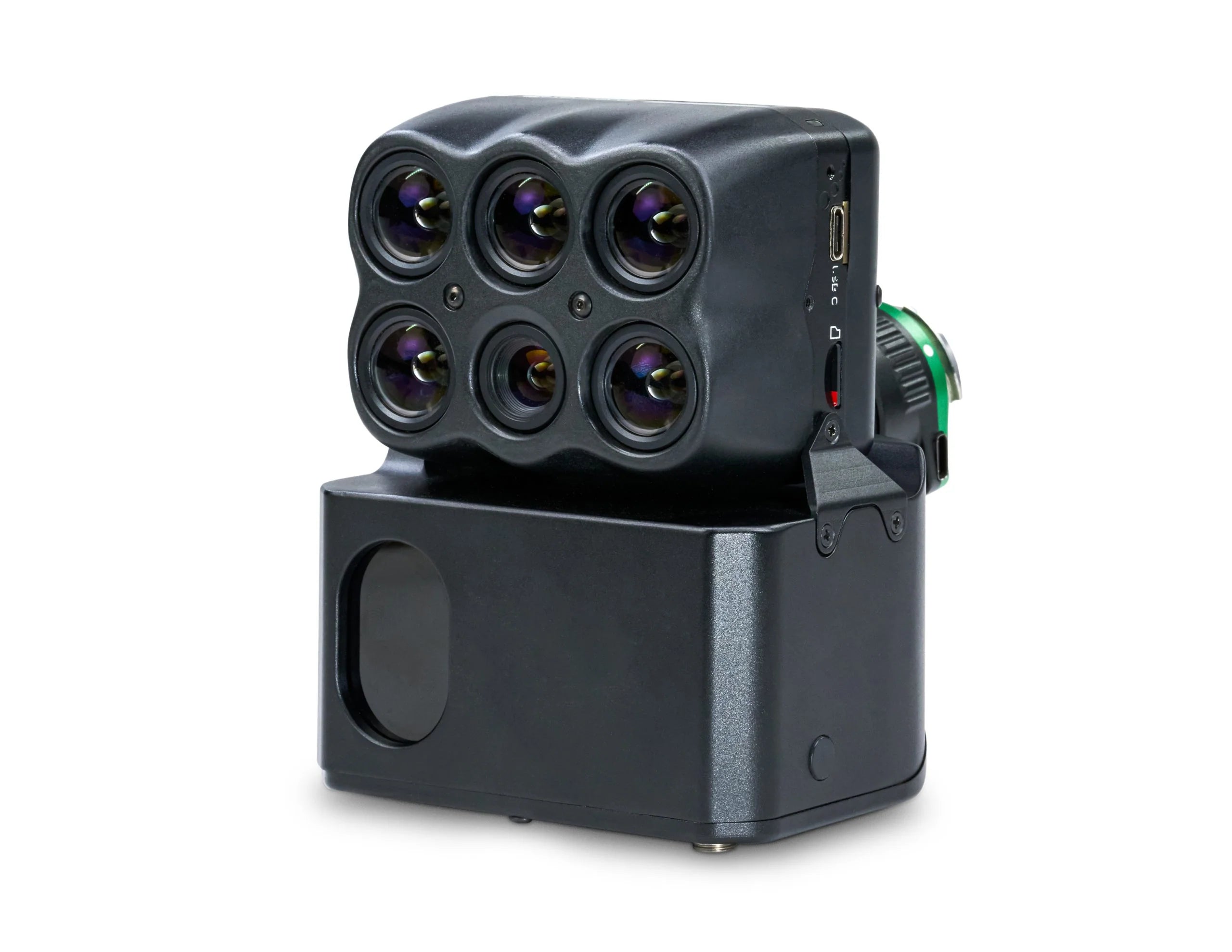
Sentera Direct Georeferencing System (DGR) with 6X/6XT Sensor
Enterprise pricing, payment terms and bulk orders — talk to a drone specialist.
Sentera Direct Georeferencing (DGR) System – 5x Faster Ag Data Delivery
Increase efficiency and reduce project time by nearly 90% with the Sentera Direct Georeferencing (DGR) System. From pre-flight planning to data capture and post-processing, this system streamlines agronomic data collection, helping industry leaders gather insights faster and focus on data validation and outcomes.
How It Works
Quick Setup & Flight Preparation
Skip the hassle of ground control points. Simply connect the DGR System to the DJI M350 RTK in just a few steps, adding tactical-grade IMU and dual RTK GPS functionality for precise geolocation.
Faster Data Capture
With a 50% reduction in image overlap, the system captures 9x fewer images, reducing flight time from 45 minutes to under 20 minutes while maintaining high accuracy.
Accelerated Data Analysis
With 5x faster data delivery, agronomic professionals can spend less time waiting for results and more time analyzing key insights, enabling faster, more precise decision-making.
Efficient Post-Processing
The Sentera DGR System delivers absolute location accuracy with spatially accurate maps generated directly in the field—eliminating the need for stitching to create an orthomosaic.
Paired with Sentera 6X Sensors for Advanced Multispectral & Thermal Imaging
Equipped with eight channels of image data, the Sentera 6X Multispectral and 6X Thermal sensors provide a fast frame rate and high radiometric accuracy, ensuring detailed, science-grade imagery for advanced agricultural analysis.
Enhanced Imagery with Radiometric Accuracy
For the most precise and reliable results, pair with Sentera’s Calibrated Reflectance Panel and Light Sensor to compensate for lighting variations, ensuring consistent and accurate multispectral data collection.
With the Sentera DGR System, agronomic professionals can capture more data in less time while achieving unmatched geolocation accuracy and analysis speed, revolutionizing precision agriculture workflows.
Enterprise pricing, payment terms and bulk orders — talk to a drone specialist.
Pairs well with
In stock! Ships within 1-2 business days.
Sentera Direct Georeferencing System (DGR) with 6X/6XT Sensor
If you have any questions, you are always welcome to contact us. We'll get back to you as soon as possible, within 24 hours on weekdays.
-
Shipping Information
We ship enterprise and commercial drone equipment across the United States. In-stock items typically ship within 1 to 2 business days. Certain enterprise, custom, and built-to-order items (such as portable rapid chargers) require additional lead time, which is confirmed at the time of order. You will receive tracking by email once your order ships. For expedited shipping, freight, or international inquiries, contact support@globaldronehq.com.
-
Customer Support
Our team helps you choose the right platform and get the most out of it. For product questions, order status, warranty claims, or technical support, reach us at support@globaldronehq.com or (858) 906-5185, Monday through Friday. As an authorized dealer for leading drone, sensor, and field-equipment brands, we help match the right solution to your mission, whether you fly for public safety, mapping, agriculture, inspection, or industrial operations.
-
FAQ’s
Are you an authorized dealer? Yes. We are an authorized dealer for the brands we carry, so your equipment includes full manufacturer warranty and support.
Do you offer quotes and purchase orders? Yes. We work with government, public safety, and commercial customers. Email support@globaldronehq.com with your requirements for a formal quote.
What payment methods do you accept? We accept major credit cards and, for approved business and agency orders, ACH or wire transfer.
How long will my order take? In-stock items ship in 1 to 2 business days. Built-to-order items have lead times confirmed at the time of order.
-
Contact Us
Global Drone HQ
Email:support@globaldronehq.com
Phone: (858) 906-5185
Hours: Monday through Friday
For sales quotes, purchase orders, and dealer or agency inquiries, email us and a specialist will respond promptly. We welcome RFQs from government, public safety, and commercial customers.